Flight Across the Pacific
Back to Stories from the Field.
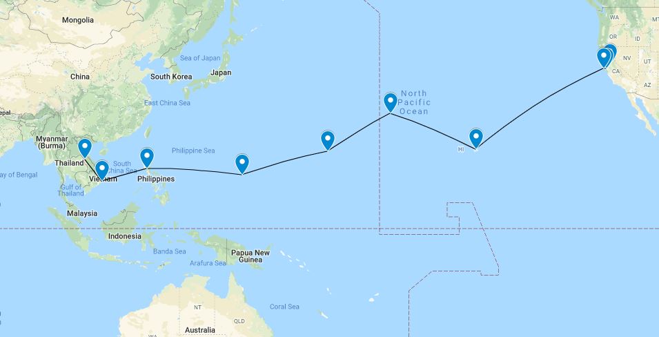
On the evening of September the 8th 1967, Juni Tengan and I were scheduled for two check rides in the A-26. On the first mission I was being evaluated by Major Oncay. I was in the right seat while Major Oncay was squeezed in behind me in the jump seat position. Juni was in the left seat. It was the quickest check ride of my Air Force career. We took off, went to the Clairbourne Range, dropped a couple of flares, made several dive bomb runs and flew back to England AFB. Our second flight was a check for Juni so Frank Gorski took the right seat and I had to wiggle into the jump seat. This mission was pretty much a repeat of the earlier one and one hour later we were approved to go to war.
At the time, the normal routine for crews going to Southeast Asia (SEA) was to take a few days leave then travel to the Philippines for the jungle survival school, then on to your assigned base. A couple of days after our check rides I was at the squadron taking care of some out-processing items. Juni was also there and he asks me about flying one of the A-26s over to Thailand. I had not even considered such a thing, but it turns out that Juni being from Hawaii, had been lining this up for sometime. I immediately said yes. I assumed that we would be part of a flight of several A-26s with some type of escort aircraft. The next day I learned that we would probably be going across by ourselves.
Being an ex KC-135 navigator, I thought about how I would navigate across the Pacific with the A-26’s minimum equipment. I wasn’t concerned about finding Hawaii but getting to Midway and Wake Island could be a challenge. I thought as long as the TACAN system worked it shouldn’t be a problem.
On the 5th of October I arrived at McClellan AFB and met up with Juni and our crew chief. Unfortunately over the years I have forgotten our crew chief’s name. We were going to be flying aircraft 651 (64-17651) and it would be ready for us in several days. On the morning of 9 October 1967, Juni and I took 651 up for a functional check flight. The airplane seemed to be in great shape: we had no problems. Most of the time was spent with me learning how to fly it, since we planned to take turns flying at one-hour intervals. Upon landing, we checked the oil consumption. We used this information to determine how much oil to pump to the engines. We would have a small barrel of oil tied in behind the right seat. A crank type pump would be used to pump the oil to each engine.
The morning of 11 October was a beautiful autumn day. We received our weather briefing and it looked very good. Enroute winds were forecast to be relatively light and mostly out of the northwest. In order to keep things simple, I broke the mission into 3 sections, computing a heading for each leg. I also computed a point of no return; just in case things did not go as planned. Climbing out from the Sacramento area we leveled off at 8,000 ft. and headed for San Francisco. About 30 miles from San Francisco we could clearly see the Golden Gate Bridge--and beyond it--the Farallon Islands. Although Juni and I had both flown this same route in the KC-135, there was a different feeling about this trip. Maybe it was the lower altitude, the slower speed, or the noise from the two Pratt & Whitney R2800 engines. Whatever it was, this seemed like more of an adventure than any of those crossings in the KC-135.
Shortly after we passed over the Farallons, Juni turned to me and said it was my turn to fly the aircraft. While I was flying the aircraft on our earlier test flight it seemed relatively easy. This was not the case however, now that we were much heavier with a full fuel load. Holding the correct heading didn’t seem to be very difficult but altitude control was another matter. We were supposed to be at 8,000 ft. but for that first hour I was usually somewhere between 7,500 and 8,500 ft. Juni didn’t say much; he just let me struggle with it and by the end of the hour I was starting to get a better feel for it. When I wasn’t flying the airplane, I would get on the HF radio and make a position report; otherwise, there was not a whole lot to do. All the aircraft’s systems were functioning perfectly--next stop Hawaii!
At the midpoint of the route we would be passing near a Coast Guard cutter known as Ocean Station November. I made radio contact with the cutter and requested a verification of our position using their radar. The operator reported that their radar system was inoperative but he would attempt to use a backup system. A minute or two later he came on the radio and reported that he could hear us just to the north of their position. The backup system being his ears! We said thanks and pressed on. As we got closer to Hawaii we were to contact an SA-16 aircraft with the call sign Duckbutt. We did make radio contact with him and attempted some DF steers to get visual contact but never did get a visual sighting on Duckbutt.
By this time, we had climbed to an altitude of 13,000 ft. and it would not be long before the Hawaiian Islands would become visible. We got a TACAN lock-on 90 miles out. I estimated we were 4-5 miles north of our intended course so we made a correction to the heading and contacted air traffic control. We flew in just south of Diamond Head and turned northwest for our approach and landing at Hickam AFB. Total flying time was 10 hours 30 minutes.
As we taxied in a “follow me” truck guided us to our parking spot where a blue Air Force bus was already waiting. Much to my surprise, as we shut down the engines, Juni’s family started coming off the bus with flower leis in hand. It was a wonderful ending to our flight. In short order Juni, myself, and our crew chief had 3 or 4 lei’s around our necks. All-in-all, it was a real Hawaiian welcome that I will always remember.
We had the following day off which gave Juni a chance to visit with his family. That evening we all attended a wonderful banquet with many of Juni’s family members and relatives.
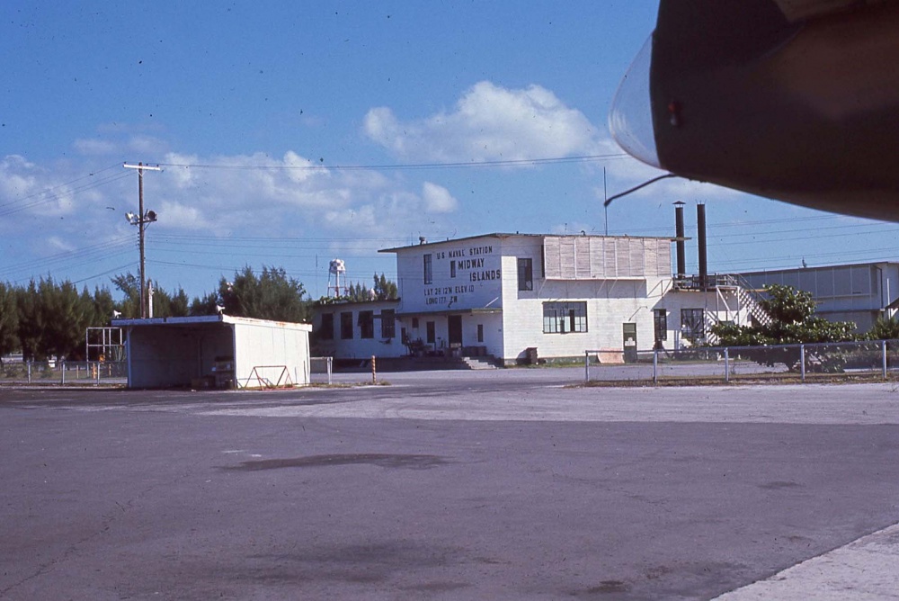
The next morning, October 12th, we departed Hickam AFB for Midway Island. Many of Juni’s family members were there to see us off. The flight to Midway was to be just under 6 hours. It was a perfect day, clear and sunny. We just followed the reefs and islands of the Hawaiian archipelago to Midway Island. We enjoyed a relaxing evening on Midway, a nice place to visit but not a place I would like to stay for a year.
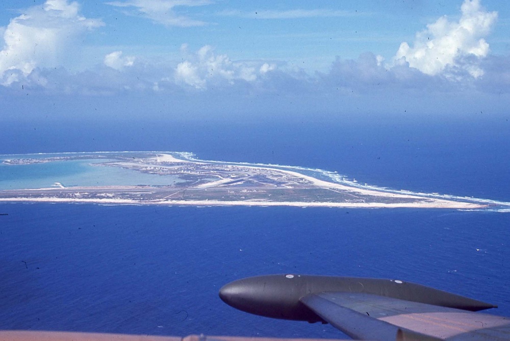
As we prepared to leave Midway, we had a short delay for some repairs. While doing the preflight inspection, I found an exhaust stack on #2 engine had broken. Fortunately, our crew chief had packed a spare one. He completed the repair in short order and we were off to Wake Island, a little over 1,000 miles away. The flight to Wake Island went smoothly and by now I had no trouble flying the aircraft on the correct altitude and heading.
We departed Wake Island for Guam the next morning. The weather was forecast to be VFR conditions our entire flight. The flight to Guam was 5 hours 40 minutes and once again aircraft 651 performed flawlessly.
As we were taxing to the transient aircraft parking area, Juni remarked that there were no other aircraft on the ramp.
After parking and going into Base Operations, we found out why. The base was under an alert for an approaching typhoon and any aircraft that could not be secured in a hanger had been evacuated to Japan. It was decided that we would ride out the storm. The weather forecasters thought that the base would not get a direct hit from the typhoon. The plan for us was to be on alert that night and if the wind started to blow more than 30 knots we would have to go to the aircraft, start the engines, and keep the nose headed directly into the wind as the storm passed.
The command post contacted Juni and me about midnight and said we would have to go to the aircraft as the wind was building rapidly. Our crew chief had obtained a pickup truck so he came by the BOQ to get us and we then proceeded to the flight line. By now it was raining heavily and wind gusts were above 30 knots. We climbed into the cockpit while the crew chief took off the tie downs. After the engines were started our crew chief headed for the pickup while Juni started aiming 651 into the wind. As the storm increased in intensity all manner of debris flew by. As we sat there watching the airspeed indicator work its way up to 70-80 knots we were amazed that we had not been hit by pieces of trees, barrels, sheet metal and other junk going by.
By daybreak things were starting to settle down and we were able to shut the engines down. Other than being very wet, everything was OK with us. Unfortunately, there was a fair amount of damage on the base, and several days passed before things started getting back to normal.
We finally departed Guam on the 20th of October and headed for Clark AB in the Philippines. The route to Clark was just over 1,400 miles and would take about 6 ½ hours. We had just passed the half way point on our route when our first systems problem started. The fuel pressure gage for #2 engine began dropping and eventually got to zero. The engine seemed to be running fine and I could not see anything abnormal. The crew chief suggested we swap the fuel pressure gages, thinking that maybe it was a gage problem. After doing that we still had zero pressure for #2. Since we still had several hours to go before reaching Clark we decided to keep the engine running even though the checklist recommended the engine be shut down since a fuel leak could lead to a fire. Once we were established on approach to Clark, Juni elected to shut it down and he made a fine single-engine landing. Later that evening, maintenance told us they found the problem and we would be OK to depart for our final destination (Nakhon Phanom) the next morning.
The morning of October 21st we received our weather briefing and it looked like we could possibly have another encounter with a typhoon. The storm was located in the middle of the South China Sea slowly moving to the north toward Hong Kong. We departed Clark AB, climbing to 10,000 ft. Our planned route would take us over Da Nang, on the Vietnam coast: then due west into Thailand. It wasn’t long before we began to see the building clouds of typhoon Dinah. Before long we were well into the storm and the rain was extremely heavy; in fact, we could not even see the windtips. The cockpit canopy leaked badly and before long we were soaking wet. Juni asked me to get on the radio and request a climb to 13,000 ft. After transmitting several times on the HF radio attempting to reach the enroute control agencies, we began to suspect the radio was not working. By now we were getting buffeted by the winds, the rain continued to be very heavy, and Saint Elmo’s fire was glowing around the entire airframe. About that time, Juni tells me he has vertigo and for me to take over the controls. While I was doing my best to keep us upright, Juni tried working the radios but had no contact. By this time we knew we should be close to Da Nang. We could see a few breaks in the weather, to the north, so we decided to get into VFR conditions, establish our position, and try to get into Da Nang. As we got a little further north, we spotted an aircraft carrier and several other navy ships.
We then realized we were close to the area known as Yankee Station. Turning to the southwest we headed to the coast and started to look for Da Nang Air Base. At this time we discovered that the VOR/TACAN systems were not working. We were unable to see Da Nang, so we stayed VFR and headed south along the coast. Eventually, we found Cam Ranh Bay Air Base, made a pass over the field, got a green light for landing, and brought this flight to a close.
However, there was a bright side to this episode. My brother, Steve, was in the Army and had recently been assigned to duty at Cam Ranh Bay as a transportation officer. After a few phone calls, I was able to make contact with him. Steve was able to join Juni and me later that evening at the Officer’s Club. The next morning he met us on the flight line and saw us off. Actually, there were a number of people there to watch us taxi out. Word had gotten around about the A-26 on the flight line. The maintenance folks had gotten all our comm/nav equipment dried out and we were ready for the final leg to Nakhon Phanom. After a smooth, uneventful flight we landed at Nakhon Phanom Air Base. The date was October 22, 1967. Our total flight time for the trip was 40 hours and 25 minutes. Seven days later, I squeezed into the jump seat behind Bill Potter and Carlos Cruz for my introduction to the Ho Chi Minh Trail.
Juni and I flew together until August 1968. He returned to duty in Hawaii flying KC-135s and I continued flying with the Nimrods until the end of September 1968. My next assignment was a C-130 squadron at Dyess AFB, Texas. Juni and I stayed in touch over the years and I visited him and his family several times. In July 2007 I spoke to him about attending the Nimrod reunion. Unfortunately, he said he was unable to attend. In late October I called to tell him about the reunion. I also sent him a copy of Roger Graham’s book “The Nimrods”. A few weeks later his wife, Chuck, notified me that Juni had passed away on the November 24, 2007.
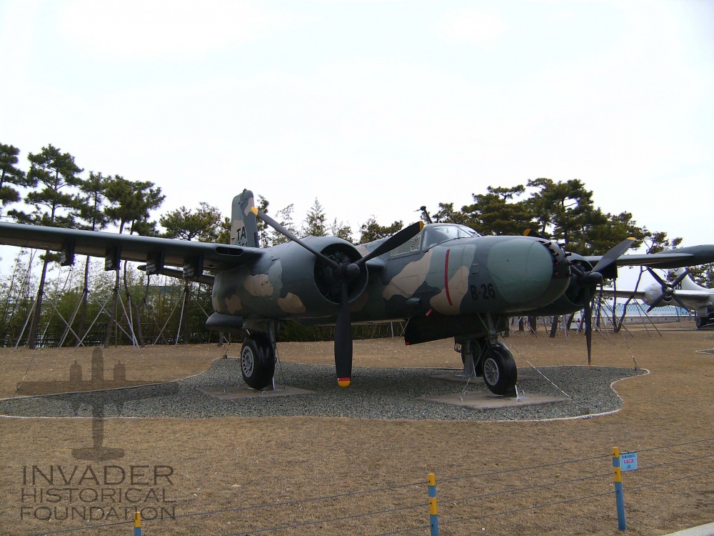
A-26 #651 survived many missions over the trail, eventually ending up in the “boneyard” at Davis Monthan AFB. Today, it is on display at the Korea Aerospace Industries (KAI) Museum in Sacheon, South Korea.
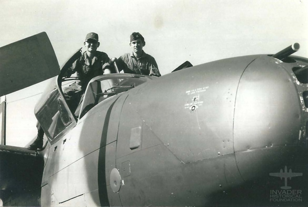
Frank Nelson (right) and brother Steve Nelson, sitting atop 64-17651 at Cam Ranh Bay Air Base, October 22, 1967.
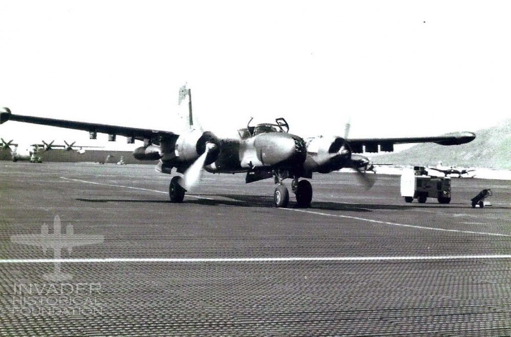
A-26 #64-17651 departing Cam Ranh Bay AB, Vietnam on final leg of flight from McClellan AFB, California to Nakhon Phanom, Thailand. Pilot, Capt. Seijun “Juni” Tengan, and navigator Frank Nelson, October 22, 1967.
A-26 #17651 on display at the Korean Aerospace Industries Museum (KAI) Photo courtesy of Don Vogler. Photographer was Abby Grace Michelsen granddaughter of Major Michael W. Michelsen, 609th SOS Nimrod navigator.
Flight Operations building on Midway Island. October 14th, 1967
Wake Island
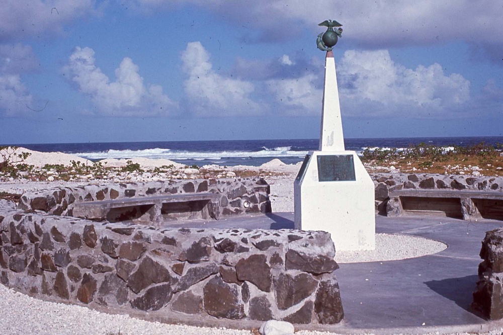
Marine Corps monument on Wake Island.
